
| Distance / Altitude | Location | Report Date / Time | Live Weather | Wind | Gusts | Temp. | Visibility | Cloud |
|---|---|---|---|---|---|---|---|---|
| 258 km W / 3 m | Aitape (Papua-New Guinea) | 2025-12-19 20:00 local (2025/12/19 10:00 GMT) | - | wind obs. (6 kph from 350 degs) was rejected (- km/h at -) | 29°C | - | no observation | |
| 261 km SSE / 1587 m | Goroka Highlands Airport (Papua-New Guinea) | 2025-12-19 19:00 local (2025/12/19 09:00 GMT) | visibility reduced by smoke | - (- km/h at -) | 22°C | 30 | - | |
| 383 km SE / 70 m | Nadzab (Papua New Guinea) | 2025-12-19 19:00 local (2025/12/19 09:00 GMT) | rain | - (- km/h at -) | 25°C | 30 | - - - | |
| 398 km S / 41 m | lightning 125km SSW of Mendi (Papua New Guinea) | 2025-12-19 19:20 local (2025/12/19 09:20 GMT) | Thunderstorm | (- km/h at -) | — | |||
| 423 km SE / 1885 m | lightning 52km NNE of Lae (Papua New Guinea) | 2025-12-19 19:50 local (2025/12/19 09:50 GMT) | Thunderstorm | (- km/h at -) | — | |||
| 471 km W / 88 m | Jayapura/Sentani Airport (Indonesia) | 2025-12-19 19:30 local (2025/12/19 09:30 GMT) | - | wind obs. (9 kph from 270 degs) was rejected (- km/h at -) | 28°C | 30 km | few scattered - | |
| 535 km SW / 125 m | Tanah Merah (Indonesia (maluku And Irian Jaya)) | 2025-12-19 19:00 local (2025/12/19 09:00 GMT) | - | wind obs. (6 kph from 30 degs) was rejected (- km/h at -) | 29°C | 30 km | mostly cloudy | |
| 649 km SSW / 30 m | lightning 49km WSW of Morehead (Papua New Guinea) | 2025-12-19 20:17 local (2025/12/19 10:17 GMT) | Thunderstorm | (- km/h at -) | — | |||
| 678 km SSE / 48 m | Port Moresby (Papua New Guinea) | 2025-12-19 19:00 local (2025/12/19 09:00 GMT) | haze | fresh winds from the SSE (30 km/h at 160) | 26°C | 20 | - - - | |
| 682 km SSE / 359 m | Port Moresby International Airport (Papua New Guinea) | 2025-12-19 18:05 local (2025/12/19 08:05 GMT) | Dry and partly cloudy | light winds from the S (11 km/h at 170) | 30°C | 10.0 | scattered scattered broken |

| Contours: | Roads & Rivers: | Select a
tide station / surf break / city |
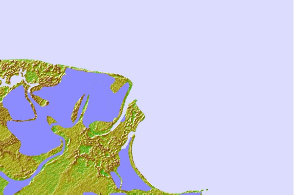
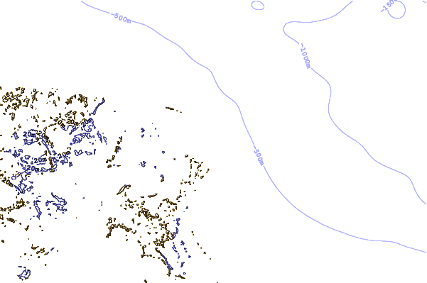

Use this relief map to navigate to tide stations, surf breaks and cities that are in the area of Sepik River, Papua New Guinea.
Other Nearby Locations' tide tables and tide charts to Sepik River, Papua New Guinea:
click location name for more details
 Surf breaks close to Sepik River, Papua New Guinea:
|
||
|---|---|---|
| Closest surf break | Forok Point | 58 mi |
| Second closest surf break | Moem Point | 63 mi |
| Third closest surf break | The Wharf (Mission Point) | 65 mi |
| Fourth closest surf break | Wewak Point | 68 mi |
| Fifth closest surf break | Cape Barabar | 71 mi |


 Nearest
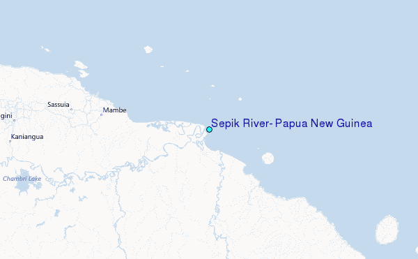