
Westerland Sea Conditions table showing wave height, swell direction and period.
High and low tide times are also provided on the table along with the moon phase and forecast weather. Sunrise today is at 08:44 AM and sunset is at 03:57 PM.
Days 1–3 Weather SummaryMostly dry. Cool air temperatures (max 10°C on Tue night, min 7°C on Mon morning). Winds decreasing (fresh winds from the SSW on Mon morning, calm by Wed morning). | Days 4–6 Weather SummarySome drizzle, heaviest during Fri morning. Low air temperatures (max 9°C on Thu night, min 4°C on Sat night). Winds decreasing (strong winds from the S on Thu night, moderate winds from the SSW by Sat afternoon). | Days 7–9 Weather SummaryMostly dry. Mild temperatures (max 5°C on Sun afternoon, min 2°C on Mon night). Winds decreasing (fresh winds from the SE on Sun morning, light winds from the E by Tue afternoon). | Days 10–12 Weather SummaryMostly dry. Freeze-thaw conditions (max 3°C on Wed afternoon, min -2°C on Thu night). Winds increasing (light winds from the NE on Wed morning, strong winds from the ENE by Thu night). | |||||||||||||||||||||||||||||||||
Monday 15 | Tuesday 16 | Wednesday 17 | Thursday 18 | Friday 19 | Saturday 20 | Sunday 21 | Monday 22 | Tuesday 23 | Wednesday 24 | Thursday 25 | Friday 26 | |||||||||||||||||||||||||
AM | PM | night | AM | PM | night | AM | PM | night | AM | PM | night | AM | PM | night | AM | PM | night | AM | PM | night | AM | PM | night | AM | PM | night | AM | PM | night | AM | PM | night | AM | PM | night | |
Wave Height Map | 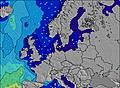 | 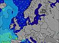 | 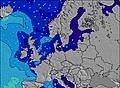 | 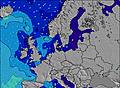 | 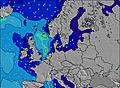 | 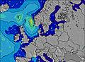 | 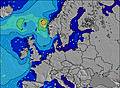 | 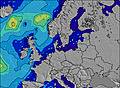 | 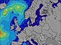 | 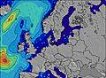 | 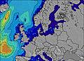 | 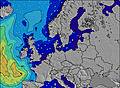 | ||||||||||||||||||||||||
High Tide | 9:02AM2.29m | 9:40PM2.12m | 10:07AM2.21m | 10:37PM2.14m | 11:03AM2.13m | 11:24PM2.17m | 11:48AM2.09m | 00:01AM2.24m | 12:24PM2.14m | 00:36AM2.38m | 12:59PM2.25m | 1:12AM2.54m | 1:38PM2.36m | 1:52AM2.66m | 2:21PM2.40m | 2:33AM2.68m | 3:04PM2.34m | 3:10AM2.62m | 3:41PM2.23m | 3:41AM2.54m | 4:15PM2.13m | 4:11AM2.50m | 4:50PM2.09m | 4:51AM2.50m | ||||||||||||
Low Tide | 3:56PM0.82m | 4:25AM0.87m | 4:57PM0.77m | 5:29AM0.76m | 5:51PM0.76m | 6:20AM0.72m | 6:34PM0.79m | 6:59AM0.73m | 7:08PM0.82m | 7:34AM0.74m | 7:42PM0.83m | 8:11AM0.74m | 8:19PM0.86m | 8:51AM0.77m | 8:58PM0.92m | 9:31AM0.81m | 9:34PM1.01m | 10:08AM0.85m | 10:09PM1.05m | 10:42AM0.85m | 10:43PM1.02m | 11:18AM0.78m | 11:23PM0.92m | |||||||||||||
WSW 8 | WSW 8 | WSW 7 | WSW 6 | WSW 6 | WSW 6 | WSW 5 | W 5 | W 4 | WSW 6 | WSW 8 | SW 6 | WSW 8 | WSW 7 | W 7 | W 7 | W 7 | W 7 | WSW 6 | WSW 6 | SE 3 | ESE 3 | ESE 3 | SE 3 | NW 13 | NW 12 | WNW 16 | NW 17 | WNW 16 | NW 14 | NNE 4 | NE 4 | NE 4 | NE 4 | NE 4 | NNE 4 | |
clear | some clouds | some clouds | some clouds | some clouds | cloudy | some clouds | cloudy | some clouds | some clouds | some clouds | some clouds | light rain | some clouds | clear | clear | clear | some clouds | cloudy | some clouds | cloudy | cloudy | cloudy | some clouds | some clouds | clear | clear | some clouds | clear | clear | cloudy | some clouds | some clouds | clear | some clouds | some clouds | |
km/h | ||||||||||||||||||||||||||||||||||||
— | — | — | — | — | — | — | — | — | — | — | — | 1 | — | — | — | — | — | — | — | — | — | — | — | — | — | — | — | — | — | — | — | — | — | — | — | |
max°C | 7 | 8 | 8 | 8 | 9 | 10 | 8 | 8 | 8 | 7 | 8 | 9 | 9 | 8 | 8 | 8 | 7 | 5 | 4 | 5 | 5 | 3 | 3 | 2 | 2 | 2 | 2 | 2 | 3 | 3 | 3 | 3 | 3 | -2 | -1 | -2 |
Moonrise | 4:04 | — | — | 5:21 | — | — | 6:39 | — | — | 7:56 | — | — | 9:04 | — | — | 9:58 | — | — | 10:36 | — | — | 11:01 | — | — | 11:17 | — | — | 11:29 | — | — | 11:38 | — | — | 11:46 | — | — |
Moonset | 1:10 | — | — | 1:21 | — | — | 1:37 | — | — | 2:02 | — | — | 2:39 | — | — | — | 3:34 | — | — | 4:44 | — | — | 6:03 | — | — | 7:27 | — | — | 8:50 | — | — | — | 10:13 | — | — | 11:36 |
8:44 | — | — | 8:45 | — | — | 8:45 | — | — | 8:47 | — | — | 8:48 | — | — | 8:48 | — | — | 8:48 | — | — | 8:48 | — | — | 8:49 | — | — | 8:49 | — | — | 8:49 | — | — | 8:51 | — | — | |
— | 3:57 | — | — | 3:59 | — | — | 3:59 | — | — | 3:59 | — | — | 3:59 | — | — | 4:00 | — | — | 4:00 | — | — | 4:00 | — | — | 4:00 | — | — | 4:01 | — | — | 4:02 | — | — | 4:02 | — | |
Today's sea temperature in Westerland is 7.0° C (Statistics for 15 Dec 1981-2005 – mean: 6.9 max: 8.2 min: 5.8°C) | ||||||||||||||||||||||||||||||||||||


 Nearest